This essay does not describe an existing computer program, just one that should exist. This essay is about a suggested student project in Java programming. This essay gives a rough overview of how it might work. I have no source, object, specifications, file layouts or anything else useful to implementing this project. Everything I have prepared to help you is right here.
This project outline is not like the artificial, tidy little problems you are spoon-fed in school, when all the facts you need are included, nothing extraneous is mentioned, the answer is fully specified, along with hints to nudge you toward a single expected canonical solution. This project is much more like the real world of messy problems where it is up to you to fully the define the end point, or a series of ever more difficult versions of this project and research the information yourself to solve them.
Everything I have to say to help you with this project is written below. I am not prepared to help you implement it; or give you any additional materials. I have too many other projects of my own.
Though I am a programmer by profession, I don’t do people’s homework for them. That just robs them of an education.
You have my full permission to implement this project in any way you please and to keep all the profits from your endeavour.
Please do not email me about this project without reading the disclaimer above.
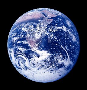
Often websites are decorated with a spinning globe. These are unrealistic. The earth spins so fast it would fly apart. There is no cloud cover. The graphics are crude. The colours are garish. The position of the sun is arbitrary having no relationship to its actual position. Ideally I want to generate an image from say one earth diameter from the center of the earth, directly above the viewer. This is the ideal, you might start with something simpler.
First you want to estimate the latitude and longitude of the viewer. You can do this from the IP. Then you want know the UTC (Coordinated Universal Time/Temps Universel Coordonné). From that you can calculate which longitude is experiencing high noon solar time. To do this properly, you need a 3D model of the earth so you can shade it dynamically and render it with any latitude closest to you. You might use this to decorate a local/UTC/other world time display.
To make it even more difficult, ask the user which way is north and render appropriately.
You could think of this as like a specialised planetarium, where you are concerned with modelling only two celestial bodies.
This page is posted |
http://mindprod.com/project/spinningglobe.html | |
Optional Replicator mirror
|
J:\mindprod\project\spinningglobe.html | |
Please read the feedback from other visitors,
or send your own feedback about the site. Contact Roedy. Please feel free to link to this page without explicit permission. | ||
| Canadian
Mind
Products
IP:[65.110.21.43] Your face IP:[216.73.217.34] |
| |
| Feedback |
You are visitor number | |